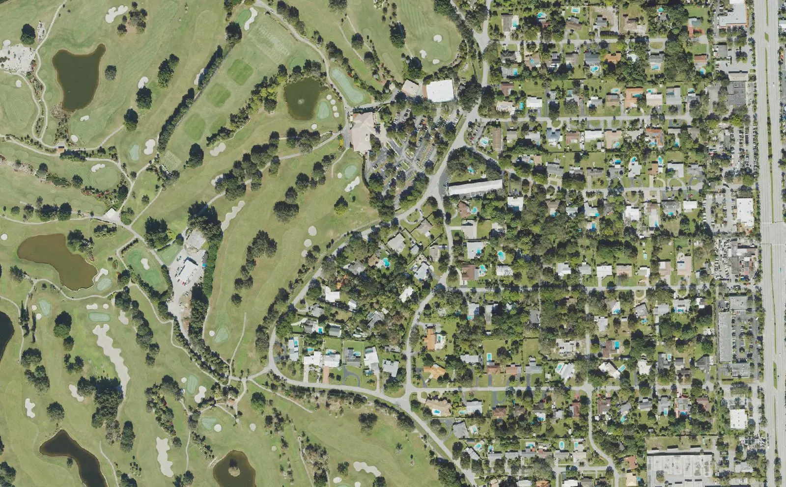
Country Club Estates, around the Fort Lauderdale Country Club golf course east of the Turnpike in ZIP 33317, is zoned for South Plantation High, an A school.
Last checked Oct. 10, 2026. Sources: the City of Plantation’s Country Club Estates Neighborhood Plan Report (PDF, 2000, Internet Archive copy) and parks directory; the Broward County Property Appraiser’s neighborhood layer; Broward County’s address points and school boundaries; the Florida Department of Education’s 2026 school grades; Zillow Research; Broward County Transit; and OpenStreetMap.
Country Club Estates is the city’s southeast corner: homes built from the late 1940s around the Fort Lauderdale Country Club golf course, between Florida’s Turnpike and State Road 7. The area was part of Plantation from the day the city was chartered in 1953. Broward County’s address data counts about 700 street addresses in the neighborhoods around the course, all in one ZIP code, and it is the closest area in this guide to the airport.
What this means for you
- Zoned high school: South Plantation High for every address, an A school in Florida’s 2026 grades. Check yours with the district’s Find My School tool.
- Home value: $543,429 in ZIP 33317 in August 2026, according to the Zillow Home Value Index.
- Nearest highway exit: Florida’s Turnpike exit 58, Sunrise Boulevard, about 2.4 miles by road; I-595 exit 6, University Drive, is about 3.6 miles.
Part of our Plantation neighborhoods guide.
Where it is
The city’s Country Club Estates Neighborhood Plan Report, dated February 2000, defines the neighborhood as about 613 acres in the southeast corner of the city, south of Broward Boulevard, east of Florida’s Turnpike and north of Peters Road, plus the homes of Plantation Point just south of Peters Road. That acreage includes the golf course. The Broward County Property Appraiser’s neighborhood layer maps the homes as Country Club Estates, Lauderdale Golf Estates, Golfview Heights and Plantation Point, about 290 acres together; this page joins them. State Road 7 runs along the eastern edge, and Park East is across Broward Boulevard to the north.
All of the area’s street addresses are in ZIP code 33317.
History. The plan says the land was first part of the City of Fort Lauderdale, which founded the Fort Lauderdale Country Club as a municipal golf course in 1926. A flood in September 1947 covered all but seven holes. Luther Remsburg began building homes beside the course in the late 1940s and early 1950s, many of them by Cravero Homes on lots of half an acre or more, and a second 18-hole course opened in 1951. When Plantation became a city in 1953, it took in the square mile southeast of Broward Boulevard and east of the Turnpike, including the club. In 1957 the Men’s Golf Association bought the 297-acre complex, making the course private.
Schools
How the area’s addresses fall in Broward County’s 2025-26 school boundary layers, with each school’s 2026 grade from the Florida Department of Education. The percentage is the share of possible points the school earned.
| Level | School | Share of addresses | 2026 grade |
|---|---|---|---|
| Elementary | Plantation Park Elementary, 875 SW 54th Ave. (report card) | 92% | A (64%) |
| Elementary | Meadowbrook Elementary, 2300 SW 46th Ave., Fort Lauderdale (report card) | 8% | C (50%) |
| Middle | Seminole Middle, 6200 SW 16th St. (report card) | 92% | B (62%) |
| Middle | New River Middle, Fort Lauderdale (report card) | 8% | B (61%) |
| High | South Plantation High, 1300 Paladin Way (report card) | 100% | A (70%) |
Peters Road is the line for the lower grades: the Meadowbrook Elementary and New River Middle addresses are in Plantation Point, south of it. Confirm an address with the district’s Find My School tool. More in our schools guide.
Home values
The typical home value in ZIP 33317 was $543,429 in August 2026, down 0.5% from $546,095 in August 2025, according to the Zillow Home Value Index. The index is a modeled typical value for the middle third of homes, single-family homes and condos together, not a sale price, and it covers the whole ZIP code, which takes in most of eastern Plantation, not just Country Club Estates. The citywide Plantation figure was $495,099, down 2.1% on the year. More in our home prices guide.
Parks and trails
From the city’s parks directory:
- Country Club Park, 1150 SW 45th Ave., at the edge of the neighborhood, with an exercise station, an open play area, pavilions, a playground and a walking trail.
- Plantation Point Park, 1200 SW 51st Ave., in Plantation Point, with a basketball court and a playground.
- Jack Carter/Harmony Park, 1301 SW 54th Ave., about a quarter mile west across the Turnpike.
- Jim Ward Park, 301 NW 46th Ave., about three-tenths of a mile north across Broward Boulevard, with tennis and basketball courts and a water playground.
The Fort Lauderdale Country Club golf course is on Country Club Circle in OpenStreetMap; the 2000 plan says it has been private since 1957. More in our parks and trails guide.
Getting around
- Highways: Florida’s Turnpike exit 58, Sunrise Boulevard, about 2.4 miles by road from the middle of the area; the Turnpike is a toll road. I-595 exit 6, University Drive, is about 3.6 miles.
- City Hall: about 3.2 miles to 400 NW 73rd Ave.
- Airport: about 7 miles to Fort Lauderdale-Hollywood International Airport, the shortest trip of any area in this guide.
- These are distances measured on the OpenStreetMap road network with the OSRM routing engine, not drive times.
- Bus: Broward County Transit routes 18 and 441 (the SR 7 Breeze) stop on State Road 7, Route 22 along Broward Boulevard and Route 30 along Peters Road, in BCT’s published schedule data for summer 2026. Check current times on BCT’s website or at 954-357-8400.
More in our getting around guide.
Homeowners associations
The city prepared the 2000 plan with the Country Club Estates Homeowners Association. The Property Appraiser’s neighborhood layer records associations named Country Club Estates, Golfview Heights, Lauderdale Golf Estates and Plantation Point. Association rules and fees are not public records we can check; ask for the governing documents before you buy.
Groceries and everyday stores
OpenStreetMap lists no supermarket inside the area. The nearest stores it maps:
- Walgreens, on State Road 7, about a sixth of a mile east
- Walgreens, 3895 W. Broward Blvd., about two-tenths of a mile north
- Publix, 3500 Davie Blvd., Fort Lauderdale, about three-quarters of a mile east
How we drew this area
This page joins the Country Club Estates, Lauderdale Golf Estates, Golfview Heights and Plantation Point polygons, and a small mobile home park polygon beside them, in the Broward County Property Appraiser’s neighborhood layer, as published by Broward County GIS, which cover the homes in the area the city’s 2000 plan describes; the golf course itself is outside them. Addresses and school shares come from every Broward County address point inside them, matched to the county’s 2025-26 school boundary layers on Oct. 10, 2026. Store and golf course locations are © OpenStreetMap contributors.
Frequently asked questions
What schools serve Country Club Estates in Plantation?
In Broward County’s 2025-26 school boundary data, every address in the area is zoned for South Plantation High, an A school in Florida’s 2026 grades. North of Peters Road the zoned schools are Plantation Park Elementary (A) and Seminole Middle (B); in Plantation Point, south of Peters Road, they are Meadowbrook Elementary (C) and New River Middle (B).
Is the Fort Lauderdale Country Club in Plantation?
It is on Country Club Circle in the city’s southeast corner. The city’s 2000 Country Club Estates Neighborhood Plan Report says Fort Lauderdale built it as a municipal golf course in 1926, that Plantation took in the area when it became a city in 1953, and that the Men’s Golf Association bought the 297-acre complex in 1957.
Is Country Club Estates a good place to live?
Here are the facts. The area’s homes cover about 290 acres around the golf course, with about 700 street addresses, Country Club Park and Plantation Point Park. It is about 7 miles by road from Fort Lauderdale-Hollywood International Airport, the shortest trip of any area in our guide, and the typical home value in ZIP 33317 was $543,429 in August 2026, according to Zillow.
What ZIP code is Country Club Estates in?
33317, for every street address in the area in Broward County’s address data.
Have your say